New Orleans, LA: C4 Mapping Tool
Courtesy of Mayor's Office of Cultural Economy, City of New Orleans
How can cultural planners develop the tools needed to fully understand a community’s resources?
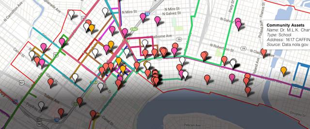
Many communities that line the Claiborne Avenue Corridor in New Orleans have faced common challenges: high unemployment, high poverty, and high vacancy rates. Since Claiborne Avenue is perceived by many in the city as a patchwork of different communities rather than as a cohesive landscape, the city was looking for ways to comprehensively plan for cultural development across the area. Hence, the New Orleans Mayor’s Office of Cultural Economy implemented a process to create an interactive web-based map—the C4 Mapping Tool—that allowed communities to provide data about cultural and economic activities, which then was fed into a dynamic resource for planners and government officials.
PLACE:
With a population of nearly 370,000, New Orleans is Louisiana’s largest city. Though the original colonial city was laid out in a grid, much of the city’s subsequent growth took the form of curvilinear corridors, shaped in part by the region’s many waterways. Claiborne Avenue is a central artery that extends across the city, from the adjoining Jefferson Parish to the St. Bernard Parish. As it snakes through the city along the Mississippi River, it passes through many different neighborhoods as a six-lane road with generous neutral ground or as an elevated expressway. The Louisiana Disaster Recovery Foundation noted, “the historic tri-parish Claiborne Corridor is a microcosm of demographic, economic, and environmental conditions in the region it traverses.” The route also connects important public services, including four current and three planned hospitals. Sitting at sea level at the edge of where a marsh once provided flood attenuation, the corridor is vulnerable to rising waters.
COMMUNITY:
As it winds through the city, the Claiborne Corridor passes through 18 census tracts defined as areas of “extreme poverty.” More than half of the residents living in the neighborhoods bisected by the roadway live below twice the poverty threshold, and between 1960 and 2000 there was a 75% drop in registered business along the corridor. Though the city has been making big strides in rebuilding following Hurricane Katrina, neighborhoods along the Claiborne Corridor are beset by high vacancy rates. Though it is a main thoroughfare, it does not provide equitable access to economic opportunity along its route due to its changing physical character, high speeds, and distance from street life in the expressway section. Over 15,500 low-wage workers commute into Orleans Parish and over 13,000 commute out, many using this integral east-west corridor.
LOCAL NEEDS:
The City of New Orleans recognized that after decades of declining economic activity, the Claiborne Corridor needed to become an area of focus for economic development. The communities along the corridor also needed to be better integrated into the economic activity along the corridor. Even though the area can be understood as one continuous stretch of transportation infrastructure, the many communities along its route each have a distinct character, and they tend to have their own approaches to planning and redevelopment efforts. Because of this patchwork approach to development, finding a cohesive strategy towards cultural development had become a challenge.
VISION:
In response to these needs, the Mayor’s Office of Cultural Economy developed what it called the Claiborne Corridor Cultural Collaborative, or C4, which was designed to bring the communities together with a shared vision of Claiborne Avenue as a continuous cultural landscape. Project Manager Alison Gavrell, a representative of the city’s Office of Cultural Economy, said the project provided a “single planning process for a variety of disparate cultural projects, breaking down silos and leveraging government and private resources.” By mapping arts initiatives along the corridor, the city would continuously provide important data to city planners, nonprofits, and developers to integrate arts and culture into development projects along Claiborne Avenue. As a provider of data, the city could more clearly communicate opportunities for the arts to become a catalyst of economic activity and new housing options.
PARTNERSHIPS:
The New Orleans Mayor’s Office of Cultural Economy took the lead in initiating the project, and it worked closely with two principal partners: Perez Architecture and the Arts Council of New Orleans (ACNO). Perez, a local architecture and planning firm, designed and constructed the online C4 mapping tool. The firm also assisted in data gathering and outreach. ACNO, a non- profit organization that works as the city’s official arts agency, had worked in the area for decades, so it was instrumental in providing data for individual artists and other non-profits. It also liaised with a range of other organizations, including the Creative Alliance of New Orleans, Oretha C. Haley Business & Merchants Association, ArtSpace, and Sankofa Community Development Corporation.
LOGISTICS:
The C4 tool, a web-based interactive map program, allowed the team to locate cultural activities along the Claiborne Corridor (for example, parade routes and festival locations) on a map of the area. This geospatial visualization allowed the community to see the corridor as a unified landscape rather than a patchwork of disparate initiatives. It also included economic data points (for example, fashion design businesses and bookstores), which, when coupled with the cultural points, allowed users to make informed decisions about zoning and place-based planning. Data collection required extensive community engagement, with partner organizations embedding themselves in the communities to solicit input from cultural businesses, workers, practitioners, and residents. To gather data from locals, Perez and the Cultural Economy Office conducted a survey, online, in hard-copy, and as face-to- face interviews. They attended 13 community meetings to advertise the survey website, hand out paper surveys, or conduct the survey orally with attendees after presenting the project in detail.
ANTICIPATED IMPACTS:
Not only did the initiative yield an extensive trove of place-based data, it rendered that data in ways that made it actionable to a diverse range of potential users. The C4 project created a map of cultural assets and linked them with other traditional planning data, including areas of concentrated blight, school locations, places of worship, and business locations. By identifying cultural activities along the corridor, it gave an added, collective voice to otherwise independent cultural organizations that are unknown to those outside their neighborhood. Once the updated and expanded version is published in 2014, the tool can be used by residents and professionals alike, in land-use planning, creative placemaking, and social initiatives. Initial feedback from urban planners and community groups describe the tool as a pattern source for decision-making, a data- gathering source for grant writing, and helpful in understanding the links between arts and zoning. One user commented: “The C4 mapping tool is a comprehensive approach to the definition of culture, yet the distinct categories provide for drill-downs to details.” Constituencies like elected officials and city administrators can also now include very place-specific considerations for future cultural activities along the corridor.
UNEXPECTED IMPACTS:
As the first of its kind, the C4 Mapping Tool provides an unprecedented perspective on cultural activities along the Claiborne Corridor. It has been able to counter the notion that cultural activities are somehow secondary to the planning process. With the tool, city planners are demonstrating that cultural programs have a material impact on the urban landscape. Due to the project’s successful outcomes, the C4 Mapping Tool has been expanded to provide information city-wide. As Project Manager Gavrell said, “It has been a revelation to our more traditional planning and capital project departments who thought that cultural assets were not relevant to their work. It also has made planners realize that cultural assets are far more diverse than just art centers, museums, and other large institutions.”
Resources:
New Orleans Cultural Economy Planning Map
An interactive web-based map of New Orleas to view area cultural, cultural economy, infrastructure, and social data.
Some participants were reluctant to provide data, since they were skeptical about how it would get used, making clear, consistent community outreach particularly important. This reluctance led to the C4 survey being available by web, on paper, and through personal interview. By building trust through transparency and explaining both the goals of the project and the anonymity option for individuals, C4 was able to receive over 450 responses for individual cultural producers and practitioners.